Introduction
Europe is home to some of the world’s most complex and expansive infrastructure projects, spanning multiple countries and regions. These cross-border connections, such as railways, highways, tunnels, energy interconnectors, and digital networks, play a crucial role in connecting people and economies across the continent. However, managing these projects presents significant challenges due to varying national regulations, complex approvals processes, and geographical factors such as difficult terrain. These challenges are further amplified when trying to coordinate across borders.
To address these issues, technologies like Scan-to-BIM (Building Information Modeling) and digital twin systems have emerged as powerful solutions. These tools help streamline project workflows, improve design coordination, and facilitate asset management, especially in large-scale cross-border infrastructure projects. However, to achieve the full potential of these technologies, several key factors need to be aligned, including standardized surveying methods, interoperable data standards, and effective governance mechanisms.
Purpose of This Guide
This guide will explore the importance of coordinated Scan-to-BIM workflows and digital twin frameworks for cross-border infrastructure projects in Europe. We will delve into the various technologies involved, the standards needed for data interoperability, the challenges of regulatory coordination, and best practices for achieving successful project outcomes. By the end of this post, readers will have a clear understanding of how these tools are transforming the landscape of European infrastructure and how to address common hurdles to successful cross-border project coordination.
Technology & Standards for Cross-Border Scanning
Scanning Methods
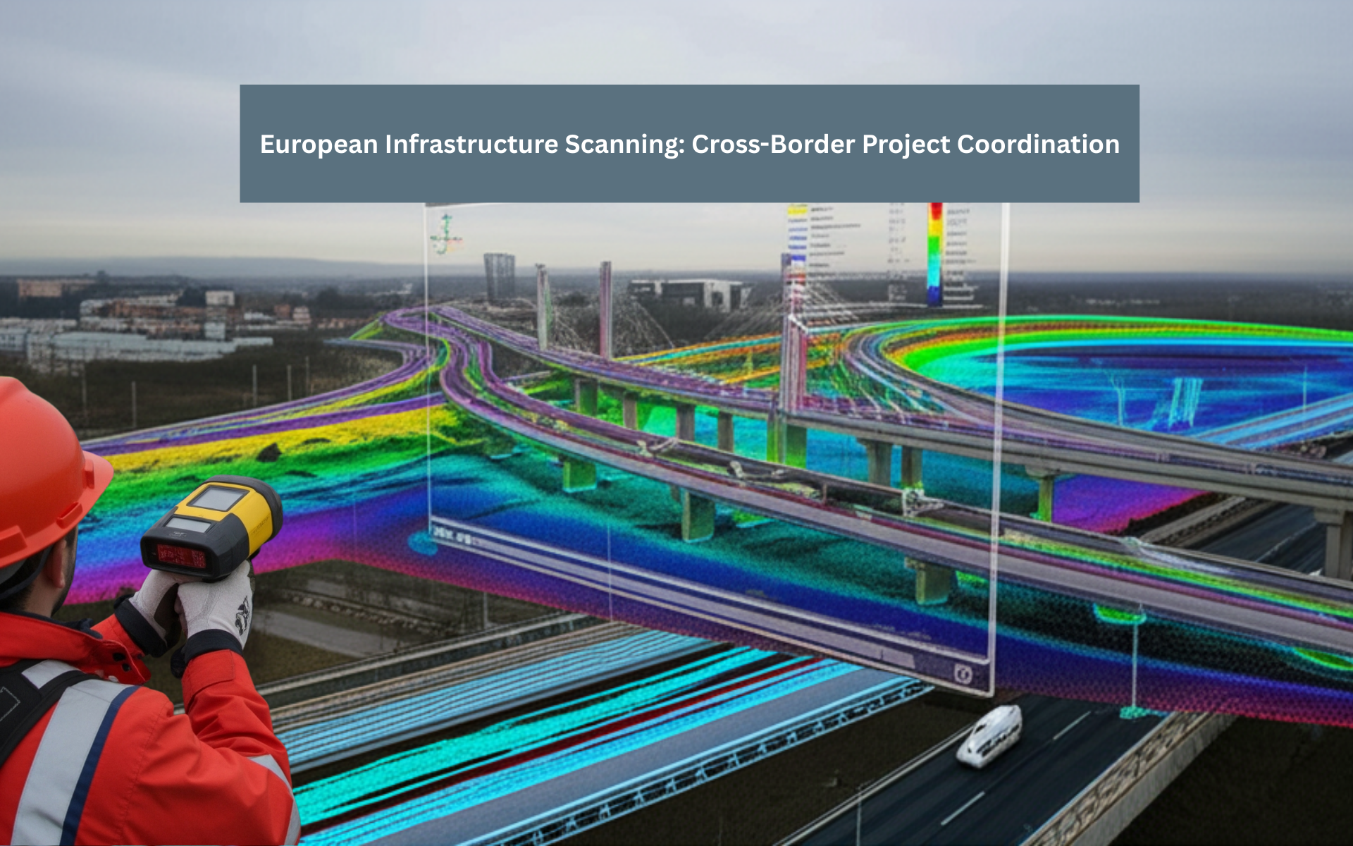
The foundation of Scan-to-BIM and digital twin workflows lies in accurate, detailed data collection. Various scanning technologies play a crucial role in gathering this data, particularly when working on cross-border infrastructure projects.
- Terrestrial LiDAR: This technology is commonly used for scanning fixed infrastructure, such as bridges, tunnels, and railways. Terrestrial LiDAR provides highly accurate 3D data that can be used to create point clouds, which are then processed into BIM models for further analysis and design coordination.
- UAV LiDAR and Photogrammetry: Unmanned Aerial Vehicles (UAVs), commonly known as drones, equipped with LiDAR sensors or cameras, are ideal for mapping remote terrains and coastlines. In cross-border projects, UAV LiDAR can help survey large areas quickly and efficiently, even in difficult-to-reach locations.
- SLAM-based Backpack Scanners: Simultaneous Localization and Mapping (SLAM) technology is used in backpack scanners, which are particularly useful for scanning confined or inaccessible spaces, such as tunnels or small border areas. SLAM scanners help create accurate 3D models by combining sensor data with real-time mapping.
Data Standards & Interoperability
For cross-border projects to be successful, the data collected through these scanning methods must be compatible across different platforms and countries. This is where data standards and interoperability become essential.
- IFC and Open BIM: Industry Foundation Classes (IFC) is a widely recognized data standard for exchanging building and infrastructure models across different software platforms. By using open BIM standards, stakeholders can ensure that the models created during the Scan-to-BIM process can be shared and used seamlessly across various systems, even in different countries.
- INSPIRE Directive: The INSPIRE (Infrastructure for Spatial Information in Europe) directive provides guidelines for harmonizing geospatial data across Europe. This includes standardizing coordinate systems, metadata, and other critical elements necessary for accurate data exchange and integration.
- Digital Twin Foundations: Digital twins are virtual replicas of physical assets, and creating a federated digital twin system across national borders is critical for infrastructure management. Initiatives like TwinEU aim to integrate national digital twins into a Pan-European framework, allowing real-time monitoring and simulation of infrastructure assets.
Regulatory & Coordination Challenges
Regulatory Fragmentation
One of the biggest hurdles in cross-border infrastructure projects is navigating the fragmented regulatory landscape across different EU member states. Each country has its permitting processes, technical standards, and approval mechanisms. This regulatory diversity can lead to delays and increased costs, making it essential to establish harmonized guidelines for projects such as the Trans-European Transport Network (TEN-T) and Trans-European Energy Network (TEN-E).
Funding & Procurement
Another challenge is coordinating funding and procurement across national and European levels. The European Investment Bank (EIB) and the Connecting Europe Facility (CEF) provide crucial financial support for cross-border infrastructure projects. However, navigating the complex rules around these funding sources and ensuring alignment with national budgets can be a difficult task. Programs like JASPERS (Joint Assistance to Support Projects in European Regions) offer advisory services, but the coordination of funding remains a complex and time-consuming process.
Cross-Border Governance
Effective governance is essential to ensure that cross-border projects proceed smoothly. Governments and stakeholders must establish inter-governmental committees to align schedules, technical requirements, and deliverables. Additionally, shared Asset Information Requirements (AIRs) must be defined to ensure that the data collected during the Scan-to-BIM process is consistent and useful across all involved countries.
Case Examples of European Scanning Coordination
4.1 Brenner Base Tunnel (Austria–Italy)
The Brenner Base Tunnel, which connects Austria and Italy, is one of the longest railway tunnels in the world. In this project, scanning teams from both countries collaborated on LiDAR surveys of tunnel portals and exploratory tunnels. The data collected was used to create synchronized BIM models that helped verify the alignment of Tunnel Boring Machines (TBMs) and ensure proper breakthrough locations.
4.2 LitPol Link Electricity Interconnector (Lithuania–Poland)
The LitPol Link is an electricity interconnector between Lithuania and Poland. To ensure accurate GIS integration and as-built BIM models, teams from both countries conducted terrestrial laser scanning of substations and right-of-way corridors. The use of unified geodetic control ensured that the data from both sides of the border could be integrated effectively.
4.3 AFR-IX Medusa Submarine Cable (Europe–North Africa)
The AFR-IX Medusa Submarine Cable connects Europe and North Africa, and it required detailed mapping of landing sites in Spain, France, and North Africa. Bathymetric LiDAR and aerial photogrammetry were used to collect data from coastal areas, which was then integrated into a federated digital twin framework under CEF funding for comprehensive lifecycle management.
4.4 TwinEU Energy Digital Twin
The TwinEU project aims to create a Pan-European digital twin system for energy infrastructure. By federating local Scan-to-BIM datasets from 11 EU countries, the project enables cross-border grid simulations and supports AI-driven model fusion for more accurate energy distribution and management.
Best Practices for Cross-Border Scan-to-BIM
- Unified Survey Protocols: To ensure consistency and accuracy, it is essential to standardize surveying protocols across all scanning teams. This includes calibrating scanners, setting up Global Navigation Satellite System (GNSS) and Real-Time Kinematic (RTK) setups, and ensuring that data collection targets such as Root Mean Square Error (RMSE) are consistently met. For terrain scans, RMSE should be below 10 cm, while for structures, it should be under 5 mm.
- Common Data Environments (CDEs): Using a Common Data Environment (CDE) for sharing point clouds, BIM models, and metadata in real-time is essential for cross-border collaboration. Cloud platforms that allow multiple stakeholders to access and update data simultaneously ensure that all teams are working with the most current and accurate information.
- Collaborative Workflows: Successful coordination requires early alignment between national scanning teams, BIM coordinators, and regulators. Holding alignment workshops at the beginning of the project can help establish shared expectations and clarify technical requirements. Developing Joint BIM Execution Plans (BEPs) with standardized Level of Detail (LOD) definitions and consistent naming conventions can also ensure smooth collaboration throughout the project lifecycle.
Actionable Recommendations
- Define Pan-European AIRs: Establish shared asset information requirements at the project’s inception to ensure consistency in data collection across borders.
- Adopt Interoperability Standards: Use standards like IFC, INSPIRE, and CEF guidelines to facilitate seamless data exchange across different systems and countries.
- Invest in Digital Twin Infrastructure: Develop federated digital twin platforms like TwinEU to bring together disparate models and real-time data for cross-border monitoring and simulation.
- Engage Stakeholders Early: Involve advisory bodies such as JASPERS and national agencies early in the scanning and BIM planning stages to streamline coordination and approvals.
Conclusion
Cross-border infrastructure projects in Europe demand careful coordination across many technical, regulatory, and financial aspects. Technologies like Scan-to-BIM and digital twins provide invaluable tools for creating accurate, detailed models that improve design, construction, and asset management. However, successful implementation requires standardized scanning methods, interoperable data standards, and strong governance structures. By adopting best practices and focusing on collaboration, Europe can build a more connected, resilient, and sustainable infrastructure network that spans borders and drives economic growth.